The tallest point in Central America is not a mountain, it’s a volcano. That’s appropriate, since we have so many of them here. It’s called Tajumulco.
We’ve been talking about climbing it since we got to Guatemala, and our time here is slipping away. My birthday was the perfect excuse to finally do this thing. A lot people hire a guide, but many of our friends had gone before and claimed it was pretty straightforward and we didn’t need one. Sounds like adventure!
Our original team consisted of four PCVs: Emily, Zach, Dan, and myself. Zach has done the climb a few times before, and would show us the way. A week before, though, he called us with bad news: he was still in terrible shape from his bout of whooping cough*, and would not be able to make the trip. “But don’t worry, it’s easy,” he said. “Just tell the bus driver you want to get off at the Tajumulco trail, and keep walking uphill. Go early, though. The rainy season is starting, so you need to get there early to have any chance of avoiding the weather.”
Other friends had warned us of the cold to be found at 14,000 feet above sea level, so we packed as we normally would for serious backpacking: tent, down sleeping bag, therma rest, rain gear, hats & mittens, trekking poles, the works- all in a giant pack. When we got on the bus with all the Guatemalans in their street clothes, we felt a little overdressed for the occasion. When we got off the bus at the dropoff, though, we realized we’d made a good decision. 40-degree drizzle, mud, and fog with fifty feet of visibility is a hard way to start a weekend outdoors even if you have the RIGHT gear. The bus pulled away, leaving us facing an abandoned-looking stone road heading uphill.
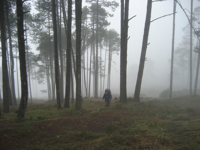
Zach’s directions proved accurate; the road just kept climbing. The visibility was so bad that we had no idea how far we’d be going; we’d heard that the hike was about five hours to the base camp below the summit. After the first hour, the road petered out and turned into a pretty poorly marked trail across grassy knolls and volcanic crags.
 “Which way do we go now?” Emily asked. I looked around, pondering.
“We follow the trash.” Yep, that is how it is in Guatemala. Everyone here is a litterbug, and we were able to guide ourselves for the next hour solely by picking our way from one piece of garbage to the next, metaphorical breadcrumbs left by previous hikers. Much of Guatemala is covered with litter, a heartbreaking contrast to the stark beauty that can be found in every square mile of this country.
 As we made our way into the higher reaches, the altitude started to affect us. Our pace slowed, and my leg muscles burned with every step, in the same way they do when I’m in the last mile of a ten-mile run. But the scenery was changing, and path was more visible as it wound between scrub pines and large ourcroppings of volcanic rock. After a few more hours, we crested a ridge. “Do you think this is it?” Dan asked.
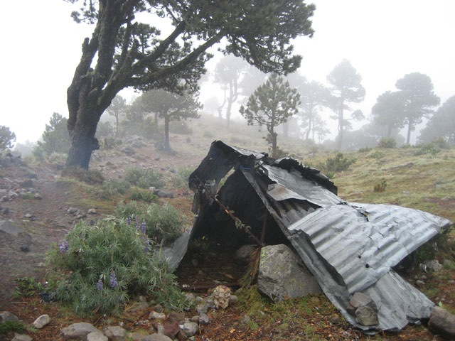
Zach had told us that the basecamp was identifyable by some scrap sheetmetal strewn about and a wooden latrine. “You guys rest, I’ll go look around,” I said. About 50 yards up the hill, I found the place Zach had mentioned… though I could not have missed it, due to the staggering amount of trash lying around. What a dump! And what a contrast to the beauty of the place. The fog was still pretty thick and the rain still drizzling, but we could make out a massive granite spur above the camp.
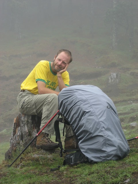
“That’s for tomorrow,” Emily said as we set up the tent. In order to catch the 5am sunrise, we’de have leave at 4am to do the final summit ascent. After the tents were up, our next challenge was dinner. Thank goodness it was only 4pm; we’d need all the remaining daylight. Normally we carry a Whisperlite stove with us when we backpack, because it is fast, convenient, and is appropriate for LNT (Leave No Trace) camping. But we didn’t bring our stove to Guatemala, largely due to airline baggage restrictions, so we had to build a fire.
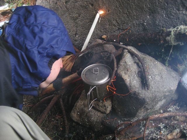
This is a tricky thing to do on a volcano at 14,000 feet in a rainstorm. I scrounged up some small sticks while Emily and Dan made a makeshift rain shelter out of sheetmetal scraps. It took about half an hour to get any fire at all, and it was a full hour before we had a cup of something warm to make dinner with. I’d sent Dan and Teresa, his Guetamalan friend, back to their tents a long time ago- no point in all of us standing in the rain being miseable. Emily took them the first cup of hot water, and we were able to get one more for ourselves before the rain finally won the battle. Here is Emily, taking her turn at Fire CPR. We wolfed down our warm dinner with gusto, thanks to my dad (who sent the freeze-dried lasagna in a care package) and Belkar (who gave me the titanium cup and spoon more than a decade ago).
We hopped in the tent, stripped off our wet clothes, and got in bed. The time? 6pm. It took about another hour to get warmed up, and the rain kept pounding against the tent. “If it’s still raining at 4am, I’m not getting up,” Emily grumbled. There really wasn’t any point; there would be no sunrise to see. We drifted into a well-earned sleep.
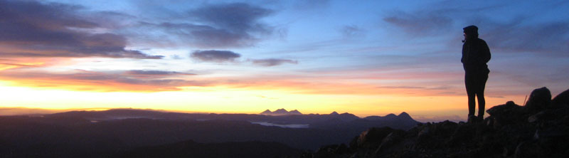
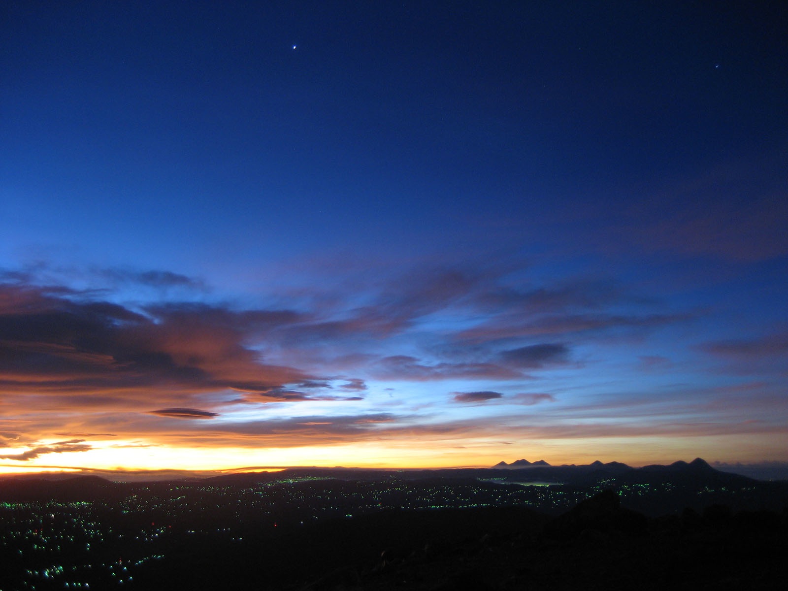
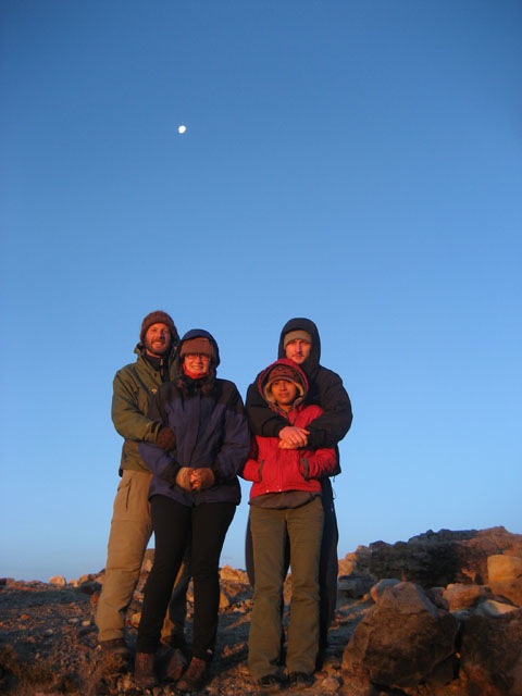
Many hours later, I woke to a blinding light. The moon! It was full a few days ago, and its presence could only mean one thing: the weather had broken. At a few minutes before 4, we climbed out of our tent into a cool, crisp night. Looking around, we were amazed at the view we’d missed yesterday; all of Guatemala was spread out below us, the tiny towns lit up like twinkling stars on a crumpled blanket of mountains. Above us, we could clearly see the volcanic spur we were to climb. We took headlamps, but didn’t need them: the moonlight etched the surface of the rocky slope, making it look like a photo from the 1969 moon landing.
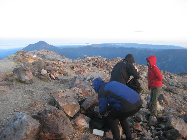
The final climb to the summit was steeper, and the air thinner, than the previous day’s work. But we’d left our packs behind, so our only remaining challenge was the cold. After two years, I still think of Guatemala as a steamy tropical country. But like our climb up Mauna Loa in Hawaii a few years back, this was yet another time we risked hypothermia in the tropics. Ice crystals were forming on all of our gear as we climbed into higher altitudes. My fingers and toes were numb from the cold, and as we crested the ridge, we were blasted by the high-altitude wind, taking our breath away. We followed the ridge to the highest point, the top of Central America, and huddled together to await the sunrise.
click on the picture to get a hi-res version you can save as a desktop for your computer
Despite the bitter cold, watching the sun rise was one of my favorite things I’ve done in Guatemala. This amazing transformation from the slumber of night to the glory of morning unfolds in such a slow, dramatic way. It reminds me of the futility of life, and this very futility is part of life’s beauty. I think about times I’ve spent with my dad, hunting and fishing, being in the woods, as I watch the miracle of dawn unfold.
What a birthday present.
By that time, some other hikers had joined us on the ridge. Many were Guatemalan, and were hooting and hollering. Why is it that Guatemalans are so darn noisy all the time? I may never know. Their guide was a friendly American (ironically), working for a local backpacking tour company, Quetzaltrekkers. We started chatting with him.
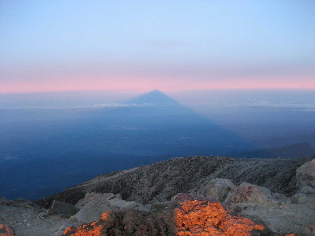 “Turn around,” the guide said. We did, and realized we’d almost missed one of the most famous views of Tajumulco. They call it a “finger shadow”, a massive shadow cast by Tajumulco in the early morning over the entire countryside of Guatemala. It stretches all the way past the Pacific ocean, which is actually visible in the photo as well (click to enlarge).
After properly soaking up the beauty, we headed back down while we could still move our extremities. Once we got moving and it seemed likely we wouldn’t lose anything to frostbite, we could take in the amazing views that were unavailable to us during yesterday’s rains. Wow! Here we see Emily making her way back down the steep face of the upper reaches of the summit. If you look closely, you can see our tents at the basecamp hundreds of feet below.

This is one of those times that I am grateful we are stationed in Guatemala, not only for the friendly people and diverse culture, but for the amazing natural wonders that can be found in every corner of this little country. In our two years here, we’ve seen ten times more of Guatemala than most Guatemalans will ever see in their lifetime. That’s the white man’s luxury, I guess. I feel like our part is to respect it, to enjoy it to its fullest, and share it with everyone else who can’t see it themselves- both Guatemalan and otherwise.
*Zach has collected a staggering array of diseases during his Peace Corps service, including dengue fever. He still hasn’t had tuberculosis, though, which has infected nearly a quarter of the PCVs in our department.